A weather update from WENA's in-house meteorologist, Garret Hartung:
As you might have heard by now, or seen on your favorite weather app/source, it’s gonna get hot this weekend. For the past several days, forecast models have been painting a dire picture for the PNW. An anomalously strong ridge of high pressure is looking to park itself over the Pacific Northwest over the weekend, paving the way for temperatures to meet or exceed records for the month of June, and potentially making a run at the hottest temperatures ever recorded in our region. For reference the highest temperature recorded in June for Portland is 102F, with the all time high temperature record being 107F. After Monday, temperatures look to calm down a bit and get back into the lower 90’s, but it will remain very dry.
So how hot will it actually get?
NWS Portland (at the time I’m writing this) is going with high temperatures at PDX of 104 for Saturday, 108 for Sunday, and 103 for Monday. Temperatures at night will be warm as well providing little relief, with some places failing to dip below 75. To me, these seem like good values to make your plans off of. However there is the a fair amount of potential for it to be even hotter. Should things line up perfectly (thermal trough parked in perfect place, offshore/downslope flow, no high clouds or smoke) there is the potential for Portland to exceed 108 and possibly even 110!
“Ok it’s gonna get hot like it usually does in the summer, why should I care?”
While tornadoes, hurricanes, and other violent forms of weather often take the top news headlines, a relatively silent killed lurks under blue skies and sunshine. According to the CDC over 650 people each year die from exposure to extreme heat and the medical complications that come with it.
 |
Here in the PNW, many are not blessed with air conditioning. This weekend will be brutal to outright dangerous for those without it. Even potentially deadly to our more vulnerable populations. On top of that, this event is happening right before the 4th of July holiday, with dry conditions persisting throughout the week leading up to it. This is setting the stage for downright scary fire conditions. There is also some concern regarding lightning in the coming week in our higher terrain. Bottom line is that this heatwave can be deadly in itself, and will likely lead to prime conditions for fires.
Some recommendations:
- Check on friends, neighbors, family, especially those who don’t have AC and/or are particularly vulnerable to excessive heat
- Do not leave pets, children, or really anything you really care about in your car. Temperatures inside can reach deadly levels within minutes in this kind of heat.
- Avoid staying outside for long periods of time. If you have to, bring a lot of water and use shade frequently. Wear loose fitting lightly colored clothes.
- Stay hydrated, drink lots of water and not too many sugary, caffeinated, and/or alcoholic beverages.
- Even if you have AC, have a backup plan in case of power outages.
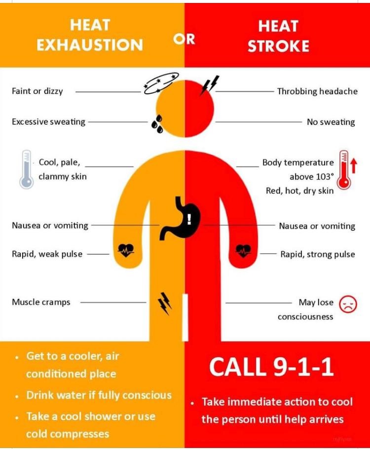
- Know the signs of heat stroke and heat exhaustion. It can save someone's life. See www.cdc.gov/disasters/extremeheat for more information.
- Reconsider stocking up on fireworks for 4th of July. I personally don’t think it’s worth the fire risk, even in the city. The fire danger could get to the point where counties ban them due to the risk of fire.
- If you live in a fire zone, have a plan if a fire breaks out near by.
- Be kind to each other. Heat like this is stressful and a lot of people will be struggling to get some sleep during this period.
Stay safe and stay smart my friends!


