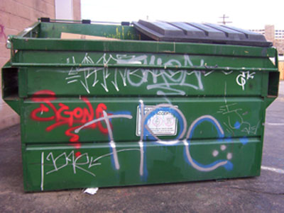
Graffiti effects everyone.
It damages our property, and it impacts our community.
Help eliminate graffiti by reporting it immediately!
To file a complaint or report graffiti:
Graffiti effects everyone.
It damages our property, and it impacts our community.
To file a complaint or report graffiti:
City of Gresham Urban Forestry Forum
Wednesday, May 23, 2007
7:00pm - 8:00pm
Fellowship Hall
Rockwood United Methodist Church
179th & SE Stark St.
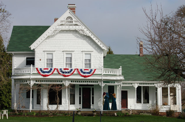 1874 Zimmerman House Gresham, Oregon. Click to enlarge |
Zimmerman Heritage Farm
A lasting vestige of
|
The historic Zimmerman House Museum is a delightful, turn-of-the-century farmhouse situated in a rapidly urbanizing area of Northwest Gresham in East Multnomah County, Oregon. The farmhouse is located at 17111 NE Sandy Blvd on 5.98 acres, a remnant parcel of the original dairy farmstead that at one time extended over 600 acres of reclaimed bottom land along the Columbia River.
The Zimmerman Heritage Farm is our cultural heritage, a lasting vestige of East Multnomah County's agricultural roots. It offers the experience of "life as it really was" in the decades at the turn of the 20th century, reflecting the past through a mirror unique to the Zimmerman family's farming and domestic life.
 Click to enlarge |
Love, Heartbreak, and RenewalLocal history says un the summer of 1845 Payton & Anna Wilkes and their seven children left Independence Missouri in a two-yolk oxen-drawn covered wagon and headed west on the Oregon Trail for Oregon. |
They arrived by late fall after crossing the Cascade Mountains during a particularly strong snow storm and settled into their new life style in Oregon City. More than 3,000 wagons arrived in Oregon that year.
In 1850 their son William Wilkes took a Donation Land Claim on Sandy Road east of Portland.
The Donation Land Claim Act (DLC) became law on September 27, 1850 as a means to promote homestead settlements in the Oregon Territory (comprising the resent-day states of Oregon, Washington, Idaho and part of Wyoming).
The Act granted 320 acres of designated areas free-of-charge to every unmarried male citizen eighteen or older, and 640 acres to every married couple arriving in the Oregon Territory before December 1, 1850. A total of 7,437 land claims were issued under the Act which expired in late 1855.
Soon after receiving his land, William gave up his claim after his wife died and headed to California to mine gold.
Rich with cash, William Wilkes returned to east Portland and purchased the Milton Frazer DLC (see photo above), which was located immediately to the east of his original claim. And that's why there are two Wilkes neighborhoods.
Wilkes, the original land claim. And, Wilkes East, the purchased land to the east of William Wilkes original claim.
 William C Wilkes Click to enlarge |
 William C Wilkes grave Click to enlarge |
 Sarah A Wilkes Click to enlarge |
To learn more about local history, read "Gresham, Stories of our Past". Available from the Gresham Historical Society, area book stores, and Amazon.com
.

|
Wilkes East Neighborhood residents info
|
|
|
Wilkes East neighborhood boundaries and statistics
|
The Wilkes East Neighborhood is located in the Northwest corner of the City of Gresham, Oregon, and is one of Gresham Oregon's sixteen neighborhoods. Wilkes East Neighborhood's borders are roughly NE Sandy Boulevard to the north, NE 181st Ave to the east, NE Glisan Street to the south, and NE 162nd Ave to the west. Get Map!
The Equity Atlas is an attempt to stimulate discussion regarding the distribution of elements seen as critical to the livability of a neighborhood. These include such things as income, single-family home price, poverty, education/teacher quality, access to usable transit, access to grocery, and more.
Click here to view the Regional Equity Atlas; Wilkes East statistics
|
|
Links to local services
|
|
|
Local Wilkes East
|


Thank You!
Wilkes East Neighborhood would like express our gratitude to the following for their generous contributions & continued support:
• Jazzy Bagels, Main St & Powell
• Parkrose Hardware, 106th & Sandy
• Growers Outlet, 162nd & Glisan
• SOLV, Bringing Oregon together
• Albertsons, 181st & Glisan
• And, all the many volunteers!

| S | M | T | W | T | F | S |
|---|---|---|---|---|---|---|
| 1 | 2 | 3 | 4 | 5 | 6 | |
| 7 | 8 | 9 | 10 | 11 | 12 | 13 |
| 14 | 15 | 16 | 17 | 18 | 19 | 20 |
| 21 | 22 | 23 | 24 | 25 | 26 | 27 |
| 28 | 29 | 30 |


